Acronyms might be regarded as the scourge of proper language. They have been undergoing an exponential explosion for years now, fueled by the growth in technology and bureaucracy. By now, there are many identical acronyms with different meanings, depending upon their context. IFR, in reference to aeronautical terms generally refers to Instrument Flight Rules, but it also has a wink- of- the- eye meaning of I Follow Roads (or rails, or rivers...). With no radio gear in my airplane, my flights are conducted according to the latter definition of IFR.
It is a hardship, but I manage. The lucky pilot who is riding through the clouds on an instrument flight plan can sit and read comic books with only the occasional interruption of a radio call. In my little plane though, I not only have to fly the plane by hand, but I also have to look out the window to see where I am going. Distractions come so easily.
When I am being proper and responsible, I am flying high, maybe even 3000 feet above the ground. From that height, on good days I can see almost forever around me, but the details of the ground below have started to blend together and flatten. The view becomes more oriented to the sky than the ground as I fly a straight line to my destination.
With the dawn coming later and later, but the winter weather still not upon us, I have had the opportunity to make several pleasant breakfast flights during the magic hour between sunup and the time when earth and sky start to react to the sun's heat. Just like people and other animals, the air goes to sleep at night. The ground chills rapidly as its heat radiates away into the open sky, and the air just above it becomes colder too. It has not been unusual this month to see the air at 4000 feet to be ten degrees warmer than the surface.
On these clear calm mornings, the air is as smooth as a mill pond because the cold air wants to stay down, and the warmer air is happy to stay higher. Morning mists form as the air near the surface becomes hazy with moisture that has evaporated from the earth. Above this haze layer the air is crystal clear, and for a hundred miles around the higher hills can be seen poking above the mists. Population centers can be noted by the inevitable plumes of moisture from factory stacks rising into the stable air, but falling back because the warmer air above prevents it from rising. The cooling towers at the Oswego nuclear plant can be seen from 75 miles away on these mornings, but the NYSEG plant on Cayuga Lake and even the cement plant in Big Flats are other good examples.
The low sun and the long shadows it casts too often tempt me though, and I find myself flying along less than a thousand feet above the ground. It is sightseeing at its concentrated best, and the scenery is as up- close and personal as though it is viewed from a car, but the birds- eye vantage means that no question need go unanswered. Where does that road go? Where does that creek start? The answers are all in view.
The trip from Beaver Dams to Weedsport can be flown by following the area's creeks and hollows. After takeoff, I follow the low ground along route 414, crossing Watkins Glen en route to the notch in the hills where Hector Falls Creek rises above Bennettsburg. Continuing towards Perry City, the ground below reaches a crest, and Taughannock Creek starts its journey northeastward to its spectacular falls en route to Cayuga Lake. Ludlowville, where Route 34B once had to zigzag down and back up a steep valley to cross Salmon Creek, is on the other side of the lake, and I fly up this valley until Locke Creek splits from it.
This valley too reaches a crest, and the southwest flow of Locke Creek becomes the northeast flowing Hemlock Creek which joins the larger Owasco Inlet Creek at Locke. Northbound now, I pass Moravia and then follow the shore of Owasco lake to Auburn at the north end.
The Finger Lakes area straddles two different geological regions, the Great Lakes plains and the Appalachin foothills. To their north, the lakes open to the flat plains, but at their southern ends, they are bracketed by hills. Once past Auburn, out onto flat land, the navigation gets more difficult because the topography does not reach up to grab you. I follow Route 5 long enough to catch sight of Cross Lake, a part of the Barge Canal system, and aim a bit west to find the airport. It is just north of where the canal dips close to the Thruway.
Flying low makes you feel like you have been somewhere. You don't look down and see lots of roads or creeks or hamlets, you see only one at a time, and each has a name. You see hunters in the woods and sometimes see the deer avoiding them. You don't see a tractor plowing a field, you see the farmer in the tractor, and you see the gulls following behind.
Just a few hundred feet of altitude leaves the world's troubles behind, and presents our blessings to behold. Curving bands of contoured fields weave across the uplands under the blue sky and every fold in the hills carries water down to the lakes. Houses look cozy against the chill of early morning, and some offer a curl of wood smoke. Country churches with tall spires stand bright in the sunshine.
The serenity and beauty are intensely satisfying. Sometimes I think back about the flight and feel as though the airplane has flown across a hundred picture postcard scenes.
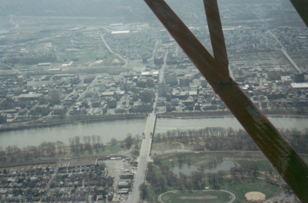
Just chugging down the Susquehanna southbound. In this case Wilkes- Barre PA is out the left window, at the far end of the bridge. This picture does not do justice to the sights that can be viewed from low altitudes, but note the posts at each corner of the span. Details like those are invisible from normal altitudes, yet are the features that give the bridge its identity. Pictures are difficult to compose because even in a slow airplane, by the time you see something interesting it has past. You have to have the camera ready, but avoid trying to fly the plane through the view-finder. I will make a special effort to take pictures next time I go canoeing in my plane, and post them to this page.